50km, 20km and 10km out and backs to kickoff the 2026 trail running season. This event is for the die hard trail fanatics providing a raw, backcountry experience. Open gender fun race, top 3 podium finish, medals and small aid stations at the 5km, 10km and 25km turnaround spots. The event is timed but only the course record will be public. This is a FREE private event therefore runners must email brandonmccluskey.ca@gmail.com to enter.
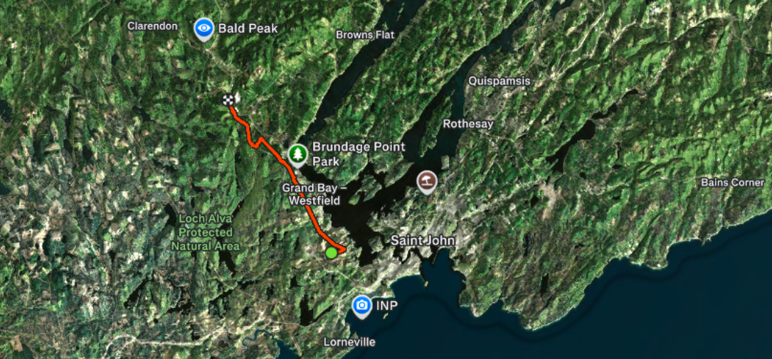
Starting at Acamac Backland Road in Saint John, New Brunswick, The Heritage Ultra-Trail 50K will take you along backcountry ATV and snowmobile trails through Grand Bay into the Mountainous Region of Welsford, New Brunswick and back. The course gets its name as a 15km section of the course in parallel to the classic Heritage Trail which passes along the Saint John River and Nerapis River.
The 10km section will take you across Mill Creek, passed Bonnell Lake, across River Valley Drive into Grand Bay, across Henderson Brook via Dorie Bridge and turns around at Colonel Nase Boulevard.
The 20km runners will continue on across Colonel Nase Boulevard, through Murray Street Bog, across Highland Road, across Milligan Brook twice, pass behind the Westfield Golf & Country Club and will turn around at Hillandale Drive.
The 50km runners will continue through remote areas parallel to the Nerapis River, cross route 102, pass through several small communities in the outskirts of Grand Bay, cross many bridges, will travel through a tunnel under the Welsford Bypass and turn around at a dead end side road with a view of the Mountains of Welsford. The total elevation for the 50km course is roughly 750 meters . Runners are recommended to bring running poles, download and follow our gps file and may fill flasks at several brooks along the way.
Heritage Ultra-Trail 50k, 20k & 10k
Saturday, April 25th, 2026
We hope that you enjoy the course and make use of it as we feel this area has been overlooked and provides an authentic variety of what New Brunswick offers. Hikers can enjoy this point A to B trip over 2 days passing many viewpoints, a wide variety of terrain with backcountry camp spots, great fishing areas and side trails which lead to many hidden gems along the way. The course is very scenic and ends with connections to viewpoints like Cochrane Lane Cliffs, Eagle Rock, Mount Douglas Bald Peak, Moose Lake, Turtle Mountain and Welsford Falls.